| Wes Boyd's Spearfish Lake Tales Contemporary Mainstream Books and Serials Online |

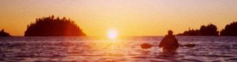
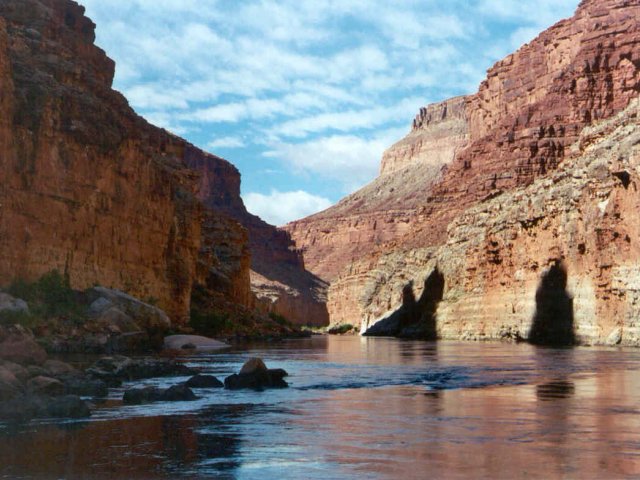
The Roaring Twenties, Redwall Cavern, Nankoweap (Mile 53)
|
| Wes Boyd's Spearfish Lake Tales Contemporary Mainstream Books and Serials Online |
In spite of the wind and rain, I must have gotten to sleep fairly easily. I awoke in the wee small hours, when everyone else was asleep, pulled on my glasses and shoes, and struggled down through the soft, sand to the river bank to empty a bladder and toast Las Vegas. As I stood there, I noticed that the wind had pretty much died to nothing, there were breaks in the clouds and stars overhead. The constellations seemed unfamiliar, until finally I picked out the southern Corvus and Crater, so realized that I was a little turned around. Soon, I was back in bed.
 |
|
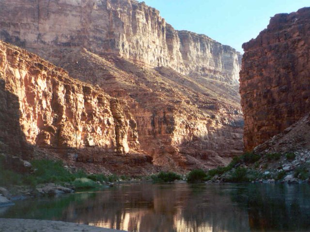
Early morning light on canyon walls at 19 1/2 Mile campsite. |
I was up early, while the boatmen were still making coffee. One of my habits in camping is to get right around in the morning, and not dink around, so I gathered my gear, tore the tent down and packed it up, then organized the rest of my stuff for the day. By the time I was finished, I'd had a cup of coffee -- the coffee bucket wasn't far away, and the boatmen were getting ready to call breakfast. Breakfast was good, scrambled eggs and hash browns, and I had a second cup of coffee as people ate and went back to tearing down.
Tearing down that first morning was a slow process for most, who hadn't gotten the message yet to get around in the morning, so we were slow getting going; finally several people had to go up and help the laggards get around. The weather was much nicer; the clouds from earlier had blown out and a clear blue sky hung jewel-like above the deep shadows of the Canyon, and everyone was in a better mood. Eventually, we got everything loaded on the rafts, and got under way.
 |
|
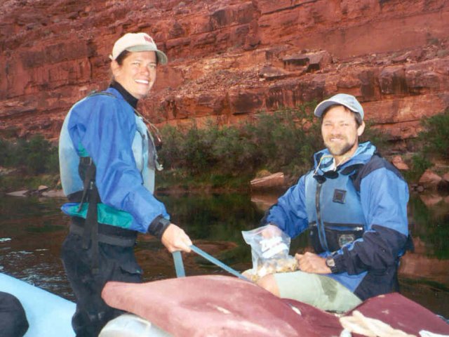
Christine Parker runs the raft, while trip leader Joe Pollock looks on. |
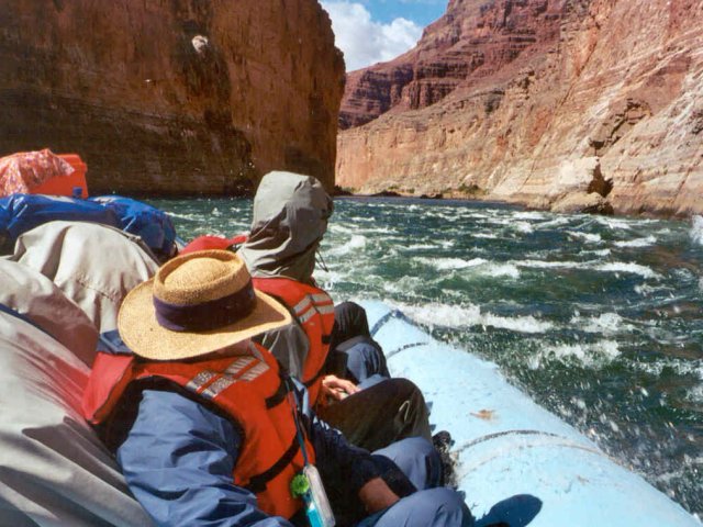
Parker was basically running the boat today. Although pretty experienced on the river -- this was her 30th trip down the Canyon -- she's now in serious training to be a boatman, and has qualifying trips to get in. She's scheduled to get her first trip with a raft of her own on August 17, but needed the experience handling the raft, and today she was to show us that it's not as simple as it looks. The rafts have no keel, and are about as happy going sideways as they are going straight ahead, and overcontrol easily. River currents will shove them about, so it takes being on your toes, even on flat water.
 |
|
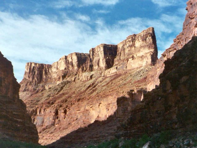
Rock formations in Marble Canyon on the morning of the second day. |
Joe had planned on stopping at North Canyon Rapid (20 Mile) for a side canyon hike, but we discovered that the Grand Canyon Expeditions group just down river got under way sooner and had already stopped there, so he decided to give it a pass, and we headed on into several miles of serious rapids -- the "Roaring Twenties" as they're known. For several miles there's a serious rapid every half mile to mile, and the worst of them is probably 24 Mile, which Parker ran clean. But at the next one, 24 1/2 mile, she got the nose of the rapid into an eddy line, didn't correct in time, and we wound up running part of the rapid backwards. Oh, well, you have to make mistakes to learn, I guess.
 |
|
Calm spot in Marble Canyon the second morning. |
As we progressed downriver, we went deeper into time. At Lee's Ferry, we were looking at Kaibab Limestone, the topmost layer of the sedimentary rock that the river cut through when that dome was rising, but not far downstream we ran into Toroweap Limestone, the next layer, somewhat older. Joe gave us a pretty good lecture about the geology -- he'd just come off a seminar trip for Canyon guides that included a geologist, and was pretty good at the geology of the Canyon anyway after five years of running the place. I'm not going to try to explain the ins and outs of it here; there are plenty of good texts about it, but here and there I will touch on it.
 |
|
In the Roaring Twenties. |
All the rocks of the Canyon, at least here and until far downstream are sedimentary, laid down by oceans and sometimes lakes and rivers long ago. As you look up the canyon walls, you can see the various layers and striations in the limestone, one of the ongoing universalities of the place. The topmost layers, like Toroweap and Kaibab Limestones, are about 250 million years old, but about 23 Mile, an older layer appears, the Redwall Limestones, which are around 350 million years old. These tend to form the more vertical layers of the Canyon, and aren't red at all, but naturally a buff color, about like what used to be the common color of computer equipment. It gets its red, and sometime black color, through an aging process called "desert varnish", in which iron oxide leaches down from higher rocks to older ones. Down near the river, and where there have been recent rockfalls, it's possible to see the true buff color of the rock.
 |
|
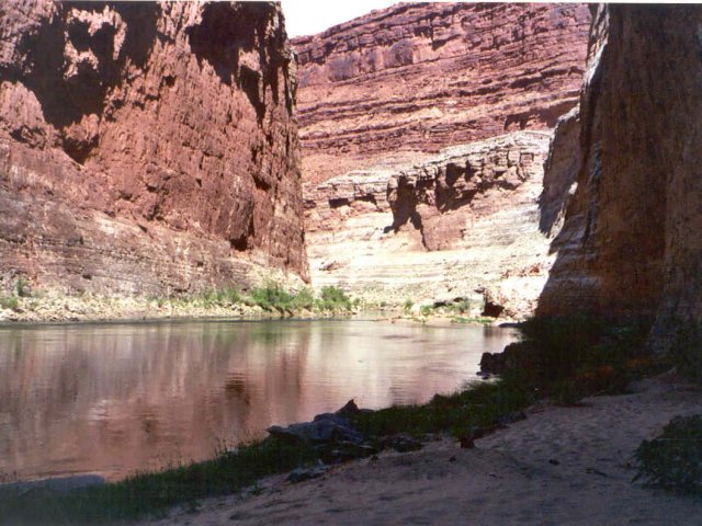
Vasey's Paradise, from in front of Stanton's Cave. |
We ran on through the rest of the Roaring Twenties -- a little muted after 25 Mile. Around 31 Mile, we pulled up at Stanton's Cave. The second major group of expeditions to survey the canyon came in the late 1800s, when the canyon was being explored for the possibility of using it as a railroad route -- which seems like madness today. It was organized by a railroad magnate from Denver, who was something of a cheapskate. He skimped on gear, including life jackets. It would have helped him; he got swept out of the boat in a rapid early in the Roaring Twenties and drowned, and two more men from the expedition drowned not much further on. At 30 Mile, Edwin Stanton, the expedition's surveyor, who was actually leading the expedition, figured they'd had enough, and stashed their gear in a cave now called "Stanton's Cave". They came back later, did the rest of the Canyon, and produced pictures and surveys still of use today; not long ago a group took copies of Stanton's pictures and tried to reproduce them from the same spots where they had to have been taken, to note how much the Canyon had changed in a century. Often, the answer is "not a lot".
 |
|
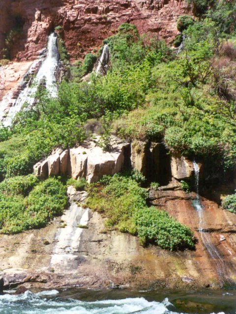
Vasey's Paradise -- pretty, with a number of tumbling waterfalls, but loaded with poison ivy, so we didn't stop. |
Only a short distance below Stanton's Cave is "Vasey's Paradise", named on the Powell Expedition. Here, a waterfall slides down the rock, making for a small spot of lush, verdant vegetation. However, we didn't stop and explore it, even though the spot is right next to the river, since the vegetation includes poison ivy and the place is lousy with it. Joe is especially sensitive to it, and decided that the place is best seen from a distance, although we got close for photos.
 |
|
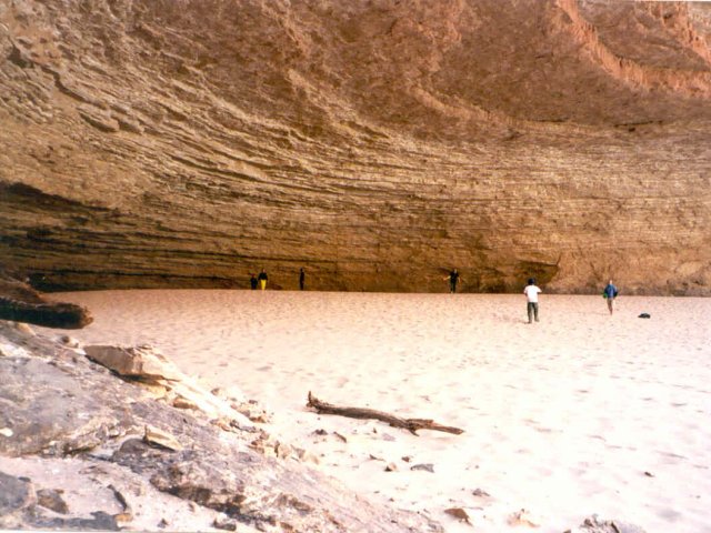
Redwall Cavern. The place is huge, but it's doubtfull that 50,000 people could be seated here like Powell said. |
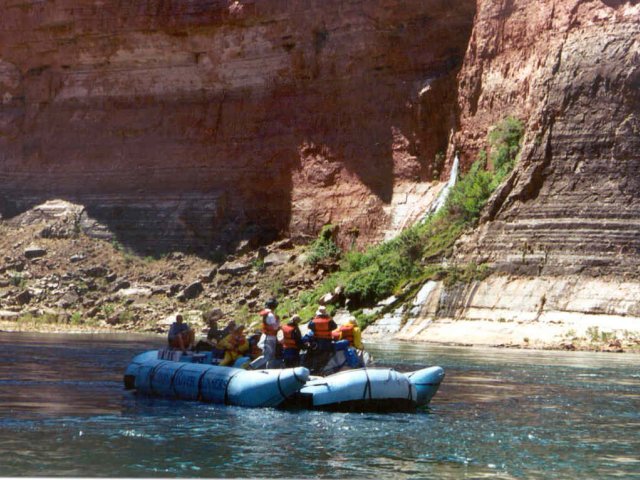
We did run on another couple miles to Redwall Cavern, one of the famous spots of the Canyon. Powell said that he thought fifty thousand people could be seated there, and while it is pretty large he probably overestimated the seating capacity by a factor of ten. The cavern, just a large undercut in the redwall, is largely filled with sand, and we pulled up on the shore to check it out. It is pretty big, and a popular stop; a private party was there, and a single-boat group from Diamond River, run by a big, happy gal who Joe was friendly with; he spent some time gamming with her while several other people threw Frisbees around, and Jason took a bunch of photos.
 |
|
View from inside Redwall Cavern. |
It was here I got the first real look at the IPIX gear that Jason was using. It's actually a pretty simple camera, but very wide angle -- 183 degrees, if I remember correctly -- and internally compensates for the wide-angle distortion. The intent is to make a full-circle image on the web page that users can point the camera around. I've not encountered it before and am looking forward to seeing how it came out.
Jason was all over the place taking photos, and he was most places. If he wasn't shooting stills, he was shooting video -- the plan is to also make a DVD or VHS video that can be used for promotions, and all of us were interviewed at least once. I do have to comment that as much and expensive as the gear was, it wasn't very well protected; Jason ran a number of rapids, filming as we went, using a garbage bag over the camera, with a hole poked through it and the bag ductaped to the lens. It did work, most of the time, but once one of the more expensive cameras got splashed pretty good, fortunately to little damage. Sand proved to be more destructive; Jason had the coating of several expensive lens scratched, and even my WR-95 got pretty well loaded with it, with the drive motor making funny sounds.
 |
|
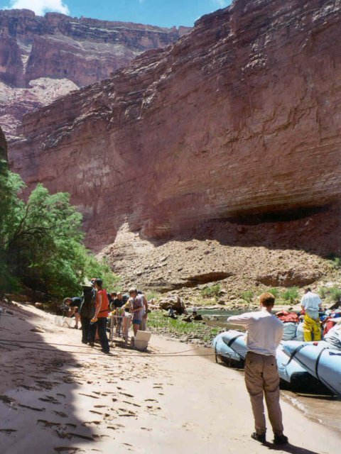
Lunch stop on the second day, just below Redwall Cavern. |
We stayed at Redwall for about an hour, I guess -- no watch -- and then ran on for a short distance, only a couple hundred yards below Redwall, and stopped for lunch, more cold cuts. By now, we were ahead of the Grand Canyon Expeditions Group, and wanted to stay that way to get a good campsite, so we just ran on, only making one short stop below President Harding Rapid (44 Mile) for more IPIX photos. "President Harding isn't much of a rapid," Joe quoted someone wryly, "But then, Harding supposedly wasn't much of a president."
 |
|
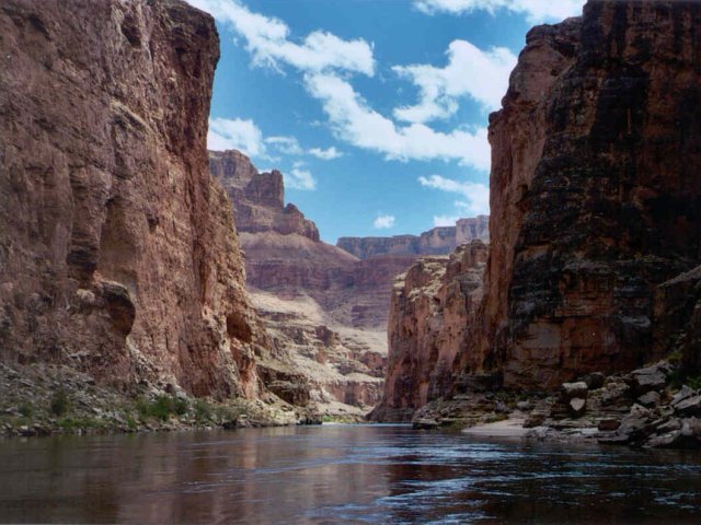
The Canyon Walls are narrow not far below Redwall Cavern. |
Really, when you get right down to it, the Colorado isn't much of a river, either. It's not a big river, in this area rarely not much over a hundred yards wide, although the continual fall makes for lots of rapids, they're mostly pool and drop rapids, and mostly not complex drops like are often seen on eastern whitewater. I can think of a number of other rivers that I've been on that are lots wider, and at times flow just as fast with just as much water. But, for the arid west, it's a big river. At least in Marble Canyon, which we were still in, it's much more enclosed than I imagined, but with continual interesting, beautiful, spectacular views. There are tons of photo opportunities; I was already rationing film, and Kathy and Jason's huge capacities seemed to make some sense.
 |
|
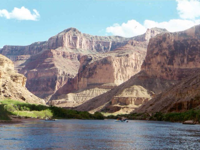
The canyon widens as we near Nankoweap. |
We ran on to Nankoweap, Mile 52, which was the first place that the Canyon widened out for a ways, to probably half a mile wide by a mile long. There are three campsites there; the upper one was already taken, and as we swept through Nankoweap rapid we could see that there was already a private party at the lower one, but the middle one was free, although there was a wide sandbar and the approach to it was shallow. The boatmen ran the boats up onto the beach so we could unload, and later moved them into deeper water to beach them again, since the river would be rising overnight and they didn't want to have the rafts out in midriver in the morning.
The river has artificial "tides" as they're called. Glen Canyon Dam is a power dam, and it runs hardest in the day, with power being cut back at night. The highs and lows flow down stream at about four miles an hour, so here, about 13 water-hours downstream, the river was low, but would be rising starting about nine in the evening, and would fall again about six in the morning. This rise would be a foot or a foot and a half, and it meant that we didn't want to camp too near the shore on the wide sand bar. A frequent question to Joe at every camp would be, "Hey, what's the deal on the tides here?"
 |
|
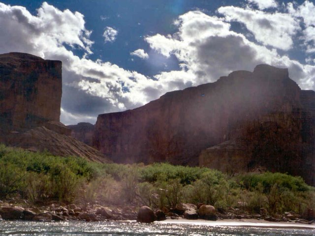
Late afternoon shadows near Nankoweap. |
I hunted around above the sand bar for a good place away from the group to put a camp, but didn't find a place that I liked that wasn't too far from the group -- or that would be easily accessible to the main camp when the tide came up, so chose a place down near the end of the sandbar, pretty well away from everything. Although there was some virga hanging from a few clouds, and we did get sprinkled on a few drops, it looked that they'd collapse when the heating of the day went away, so I decided to sleep out that night, although the spot was rather soft sand. While I very much enjoy sleeping out under the stars, in the east I rarely get a chance to do it, due to mosquitoes, and, more importantly, dew -- but here there are no mosquitoes, although occasional sand flies and gnats, and it's so dry that dew is unheard of, so I proposed to make the best of the opportunity. I spread out the ground cloth from the overnight bag, lay my gear down on it to keep it from blowing away in the occasionally gusty breeze, and started organizing things for overnight. The big problem in camping down in the Canyon on the sand bars is that the sand gets into everything, no matter what you try to do to keep it under control. You try to do what you can but you still live in it -- no wonder that the boatmen take the perogative of sleeping on the boats, the situation is a little better.
 |
|
Second night camp at Nankoweap. |
While I sat and organized gear, several of the party dug out fishing rods and went fishing. Once upon a time, fishing in the Canyon was nothing much, but the clear, cold water from Glen Canyon dam now supports a heck of a trout population, and the trout fishing was excellent. A few people threw flies around, but most used small spinners and ultralight tackle, and the more serious fisherpeople had trout most nights, grilled once the main dinner was out of the way. If I ever do the Canyon again, I think I may haul along a small fishing outfit, although most of the time I couldn't catch fish with dynamite.
About the time I had things pretty well together, the boatmen called for dinner, and I wandered down to see what was on the menu tonight -- barbecued chicken and pretty good, too. As always, it was getting dark by the time that we got finished, and once the dishes were done, Joe threw part of a Dura-Log into the charcoal of the grill, and we had a little campfire. Gathering driftwood for campfires isn't allowed in the summer months, at least May-September, and the ashes have to be carried out, so the Dura-Log would have to do, and it did pretty well, although it smelled pretty awful and you really wanted to be out of the smoke.
Several of us sat around talking, watching the fire, and working on beers. As much beer and pop as we were drinking, it would be not be possible to carry ice enough to keep it cold, but it doesn't matter -- the water out of Glen Canyon Dam comes out of the bottom of the lake, and it's cold, usually about 45 degrees, making swimming uncomfortable, but just right for other things. The rafts each tow several nylon mesh bags known as "drag bags", filled with pop and beer, and there's always a mixture of stuff in it. You're kind of on the honor system for drinking your own beer. As much MGD as came along -- and I wasn't the only one bringing it -- getting a beer almost always turned into an MGD hunt. I usually managed to find one or two, which was about all I wanted to drink, anyway. In our group, we usually kept the beer for the evening, although later in the summer, when it gets real hot, I'm told that the beer starts flowing early in the day, and there's lots more along.
I finished my beer for the night, crushed the can -- the empties have to go in an old onion bag brought along for the purpose -- and headed off to where my sleeping bag awaited. Since it proposed to be a much nicer night than the one before, I peeled out of my clothes, pulled on my lightweight polypro underwear, and went to bed as the stars were beginning to peek out.


